


Navionics+ Australia Nautical Marine Map | Compatible with Garmin GPS | Detailed Coverage | High-Res Relief | 3D View
Navionics
$344.18
(No reviews yet)

Write a Review
Navionics
Navionics+ Australia Nautical Marine Map | Compatible with Garmin GPS | Detailed Coverage | High-Res Relief | 3D View
Important: Product images may not represent the actual item and may include generic, demonstrative, or compatibility examples. Please carefully review the product title, description, and specifications to understand what is included in your purchase.
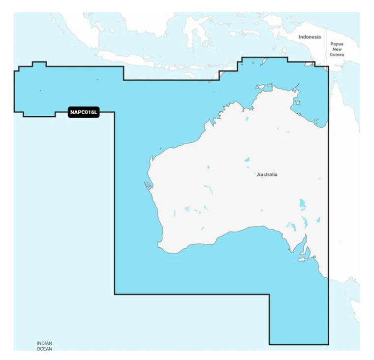
Note: Marine Cartography, Navionics®+, Compatible With Garmin GPS Navigation Systems/ Chart Plotters, Detailed Coverage Of Australia, West And Central - Inland and Coastal, Region Code: NAPC016L, On SD/Micro-SD Card, One-Year Subscription, With Auto Guidance Technology, High-Resolution Relief Shading, High-Resolution Satellite Imagery, Aerial Photography, 3D View
Key Features
- Navigate With Our Best Offshore And Inland Lake Coverage For Your Compatible Chartplotte
- See It Your Way: Customize Your View With Various Chart Layers And Overlay Combinations
- With Your Provided 1-Year Subscription, Access Daily Updates Via The Navionics® Chart Installer Software
- Advanced Route Guidance Technology2 Lets You Navigate With Suggested Dock-To-Dock Routings
- Selectable Map Options Let You Highlight Shallow Areas, Adjust Contour Density Or Select A Fishing Range
- Access Detail-Rich Mapping Of Coastal Features, Lakes, Rivers And More On A Wide Range Of Compatible Chartplotters
- For Improved Fishing And Navigation, Up To 0,5 Meter Contours Provide A Clear Depiction Of Bottom Structure For Fishing Charts As Well As Enhanced Detail In Swamps, Canals, Harbors, Marinas And More
- Change The Way You View Navionics Charts To Focus On The Details That Matter Most To You: Highlight Shallow Areas, Adjust Contour Density, Or Select A Fishing Range
- Unique 3D Views Provide Additional Perspective, Both Above And Below The Water’s Surface, To Highlight Key Features And Aid In Situational Awareness
- Limited 1 Year Warranty
Technical Details
- Compatibility: Garmin GPS Navigation Systems/ Chart Plotters
- Chart Coverage: Detailed Coverage Of Australia/ West And Central - Inland And Coastal
- Storage: On SD/ Micro-SD Card
